
Blog ·
What is a hook echo?
The radar signature that named this app: what makes the hook, why it means a tornado might be underneath it, and how to spot one yourself.
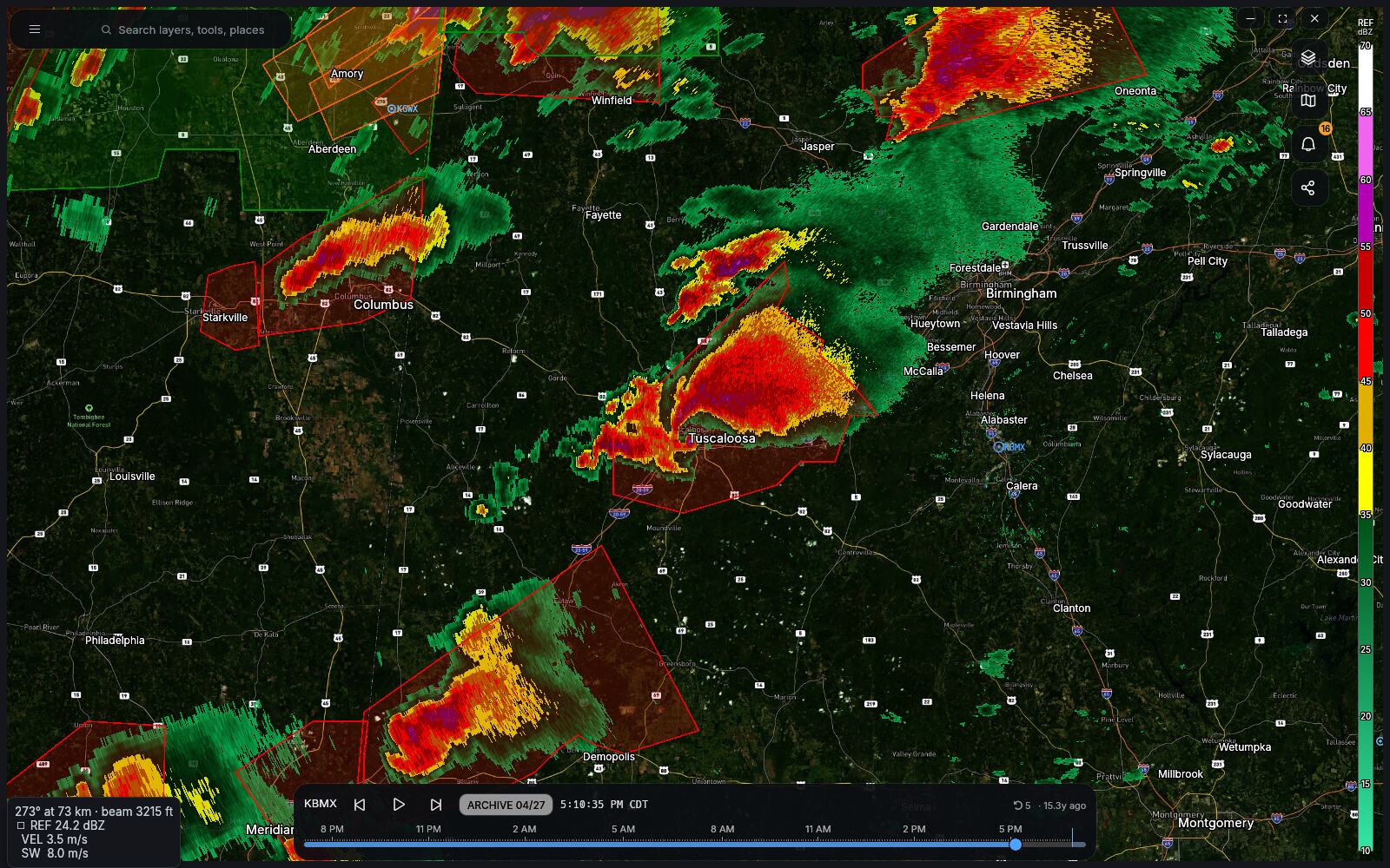
On 9 April 1953, a radar operator at the Illinois State Water Survey named Donald Staggs was watching a thunderstorm near Champaign and saw the echo grow a tail — a thin finger of returned energy curling off the storm’s south side into an almost complete circle. A tornado hit Willard Airport at about the same moment.
It was the first time anyone had put a radar picture next to a tornado and found a shape. Seventy years later it is still one of the first things a forecaster looks for, and it is where this app got its name.
What actually makes the hook
A supercell is a thunderstorm with a rotating updraft — a column of rising air several miles wide, turning. The rotation comes from wind shear: wind that changes speed and direction with height rolls the air into a horizontal tube, and the updraft tilts that tube upright.
Rain and hail fall out of the back of the storm. If the storm is rotating, that falling precipitation gets dragged around the outside of the updraft, the way milk wraps around a spoon. On reflectivity — which is just a picture of how much precipitation is in the beam — that wrap draws a curl hooking off the back-right of the storm.
The hook is precipitation. The thing that matters is the empty space it curls around: that hole is the updraft, and if a tornado exists, that’s where it is.
Why a hook is not a tornado
This is the part every guide gets wrong by omission. A hook echo means a storm is rotating on the scale of the whole updraft — a mesocyclone, several miles across. Tornadoes are a hundred yards across. Most mesocyclones never produce one.
Radar also cannot see the tornado directly in reflectivity. The beam climbs as it travels, so at 60 miles out even the lowest tilt is thousands of feet above the ground, looking clean over the top of whatever is happening underneath.
So the hook is a reason to look harder. It isn’t the answer.
What confirms it
Modern radar gives you two more things, and the combination is what forecasters actually issue warnings on:
Velocity. The radar measures whether the echo is moving toward it or away from it. Rotation shows up as green (toward) directly against red (away) over a short distance — a couplet. A tight couplet at the base of the hook is the mesocyclone, measured rather than inferred.
Correlation coefficient. Dual-polarization radar can tell whether everything in the beam looks alike. Raindrops do. Fence posts, roof shingles, insulation and shredded trees do not. When a tornado is on the ground it lofts all of that into the air, and CC collapses in a small blob right where the couplet is. This is the tornado debris signature, and it is as close to proof as radar gets: it means something down there is being torn apart, right now.
Hook plus couplet plus a hole in CC, all in the same place at low tilt, is the picture that ends the argument.
Seeing one yourself
Every archived storm in the American record is available, free, and HookEcho plays it back the same way it plays back live weather. If you want to see a textbook hook, load KTLX for 20 May 2013 and scrub through the afternoon — Moore, Oklahoma — or KBMX for 27 April 2011. Put reflectivity, velocity and correlation coefficient in four panes on the same storm at the same second, and the three signatures line up in front of you.
That’s a better explanation than this article is.
- Reading the radar — the products, in plain language.
- Get HookEcho, or open it in your browser.
Comments
Threads live in GitHub Discussions. Signing in uses your GitHub account — we never see a password, and there is nothing to create.